Health & Fitness
A Chilly Week
Will there be any snow accumulation today? Find out in this week's PatchCast!
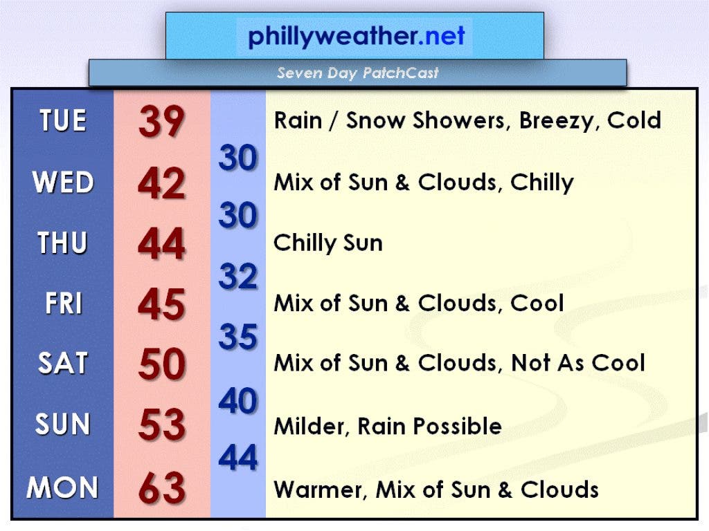
A low pressure system off the coast will bring us rain and snow showers today, November 27th. Little or no accumulation is expected along I-95 and south/east. An inch or two is possible in the hills north/west of Philadelphia. It will be a breezy and cold day with a high near 40 for most of us. However, farther south and east it will be between 45 and 50 degrees. The rain and snow showers will end this evening.
Wednesday, November 28th, will be a chilly day with a mix of sun and clouds. The high will be in the low 40s.
High pressure will take over on Thursday, November 29th, clearing out our skies but temperatures will remain chilly. The high will be near 45.
Find out what's happening in Collingswoodwith free, real-time updates from Patch.
That high pressure system will weaken on Friday, November 30th, so there may be a few more clouds around at times. Temperatures will still be cool in the mid 40s.
A warm front will approach this weekend. Consequently, Saturday, December 1st, won't be quite as cool with a high around 50. A disturbance will move through on Sunday, December 2nd, so some rain will be possible then with a high in the low 50s.
Find out what's happening in Collingswoodwith free, real-time updates from Patch.
To start the new work/school week on Monday, December 3rd, temperatures will be much warmer behind the weekend's disturbance. High temperatures will be between 60 and 65 degrees!
If you don't like this week's chill, hang in there because it will temporarily ease at the beginning of next week. Be sure to check in with Phillyweather.net for your latest forecast!