Health & Fitness
Hurricane Sandy Bears Down on New Jersey
The latest information on Hurricane Sandy and things you need to know to be prepared for this historic storm can be found here.
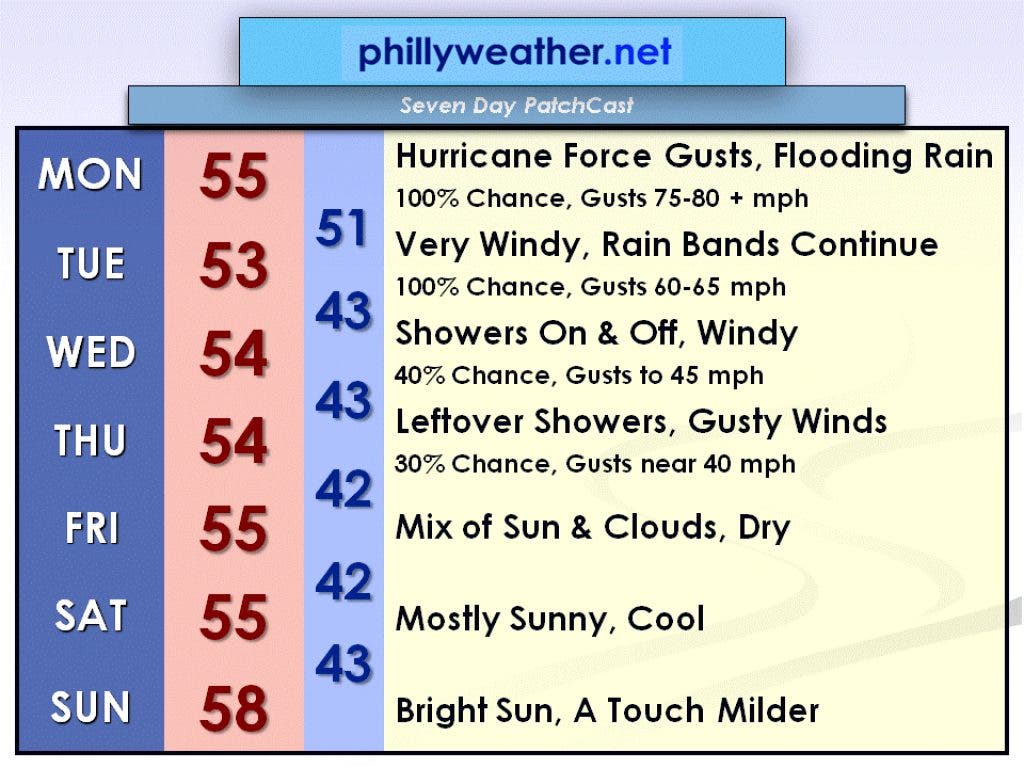

Hurricane Sandy will be making landfall Monday evening somewhere between southern Delaware and New York City. New York City and western Long Island are going to be two of the hardest hit areas from this storm because the strongest winds are found on the northeastern side of the eyewall (the area surrounding the eye, or center, of the hurricane), which will likely pass just to the south and west of New York City. Even though Sandy is only a category one hurricane on the Saffir-Simpson Scale, the behavior of the storm may be more comparable to that of a major hurricane (category three or higher) due to its extremely low pressure (in millibars). As of 5 PM Sunday, Sandy has a minimum central pressure of 952 millibars which is more typical to the minimum central pressure of a category three hurricane (see the attached image).
I am expecting 6 to 12 inches of rain for the Delaware Valley from now through Thursday, with most of it falling Monday through Tuesday. The worst of the wind will be from Monday morning through Tuesday morning. In fact, the National Weather Service in Mount Holly has issued a High Wind Warning from 8 AM Monday until 9 AM Tuesday. Monday night will be a sleepless night for many of us as sustained winds of 40 to 50 mph with gusts of 75 to 80 + mph shake our houses.
Be aware that such strong winds could cause widespread power outages and lots of downed trees. If you live in flood-prone area, be on the lookout for flooding due to prolonged periods of heavy rain. If you remember Hurricane Irene from last August…I believe it will be worse than that. If you come across a flooded roadway, turn around…don’t drown.
Find out what's happening in Collingswoodwith free, real-time updates from Patch.
In preparation for a prolonged power outage, you will want to follow the following checklist of things to have: flashlights, candles or matches, a battery operated radio, non-perishable food, bottled water, a way to charge your cell phone (via your car?), gas in your car, gas for your generator (if you’re lucky to have one), cash on hand, and bags of ice if necessary.
We will be dealing with on and off rain from the remnants of Sandy through Thursday. The worst weather will occur on Monday and Tuesday with heavy rain and tropical storm to hurricane force wind gusts. The weather will slowly improve beyond that as Sandy’s remnants move off toward the north and east. However, cooler air will be locked in behind an area low pressure aloft. Right now, it appears that Friday through the weekend will be drier as high pressure begins to build in from the west.
Find out what's happening in Collingswoodwith free, real-time updates from Patch.
Make sure you check in with Phillyweather.net for periodic updates on Hurricane Sandy! For the latest forecast track of Hurricane Sandy, go to the National Hurricane Center's website.