Health & Fitness
A Typical August Week Ahead
What day will be the driest this week? What day will be the wettest? Find out in the PatchCast for August 6 through August 12.
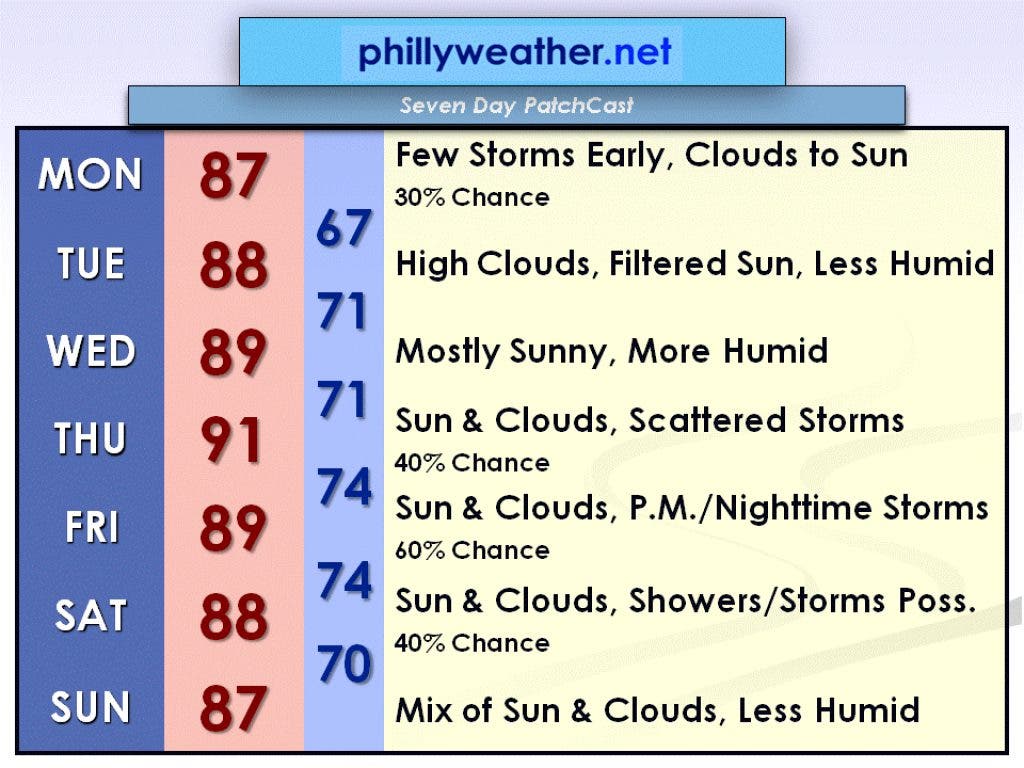
A warm week is in store for the Delaware Valley with sun and thunderstorm chances. No particular day should be a washout, but the wettest day looks to be Friday. Tuesday will definitely be the day with the best weather this week with mostly sunny skies and low humidity.
A departing low pressure system with its associated cold front will cause a risk for a few showers or thunderstorms this morning, but the afternoon will feature brightening skies. I can't totally rule out a shower or thunderstorm this afternoon, but you'd have to be really unlucky to see one where you live.
The high today, August 6, will be in the mid-80s. Humidity levels will be dropping this afternoon, so it will feel more comfortable as you get out of work this evening.
Find out what's happening in Collingswoodwith free, real-time updates from Patch.
High pressure will build in for Tuesday, August 7, bringing us dry weather. In simplest terms, skies will be mostly sunny. In technical terms, the sunshine will mix with high thin cirrus clouds causing more of a filtered appearance to the sun. Overall, it will be a beautiful day with low humidity and a high in the upper 80s.
High pressure will move off the coast on Wednesday, August 8, causing the humidity to increase again. However, skies will remain mostly sunny with the high pressure system still nearby. The high will be near 90 degrees.
Find out what's happening in Collingswoodwith free, real-time updates from Patch.
On Thursday, August 9, a cold front will be approaching from the north and a warm front will be approaching from the south. These fronts will team up and cause at least a scattering of showers and thunderstorms, but not everyone will get wet. The high will be around 90 degrees.
Friday, August 10, will be the most unsettled day of the week with the warm front barely to our north. It is tricky to determine the exact position of the front five days out, so this forecast may very well have to be adjusted later in the week.
If the front does make it north of the Delaware Valley as I am currently forecasting, it will be a very warm and humid day with a high temperature near 90 degrees. As the warm front continues to move north, a cold front associated with an area of low pressure will approach from the west. This means that our chance of thunderstorms will increase through the day and storms will likely last through the nighttime hours.
With the cold front still nearby on Saturday, August 11, I can't rule out a few more showers or thunderstorms, but not everyone will get wet. Humidity will be a touch less behind the front, but it will still be warm with a high in the upper 80s.
You will really feel a decrease in the humidity by Sunday, August 12. Right now it looks like it will be a nice day with a mix of sun and clouds and a high in the mid-80s.
Be sure to check in with Phillyweather.net this week for updated forecasts. Have a great week!